AT A GLANCE
The plan’s most consequential numbers.
These figures are from the August 3 engineering packet. The site data identifies the current use as single-family residential and the proposed use as a convenience store, lube and detail shop, outdoor vacuums, and a car wash tunnel. The August engineering drawing labels the fueling area “8 pumps” and approximately 3.50 acres of disturbed limits. The older June sketch distributed in the September meeting packet appears to label four pumps; the applicant should reconcile the versions. This page uses the August engineering label of eight pumps.
SITE & HOMES
Car wash and vacuum activity at the residential edge.
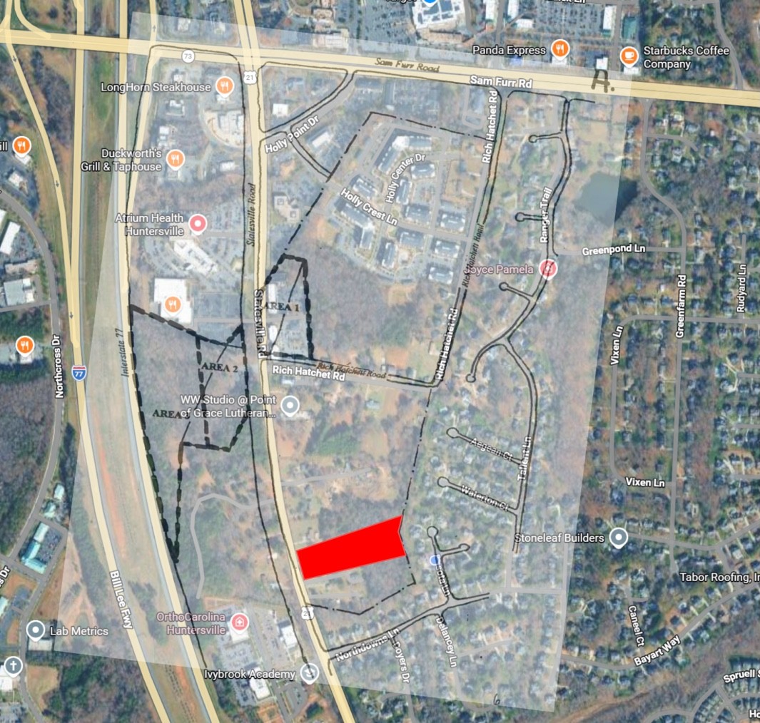
Statesville Road is on the left of the plan. The convenience store and gas pumps sit toward the road; the detail and lube building occupies the middle; the car wash and 18 vacuum bays sit toward the rear. Residential parcels surround the sides and rear.
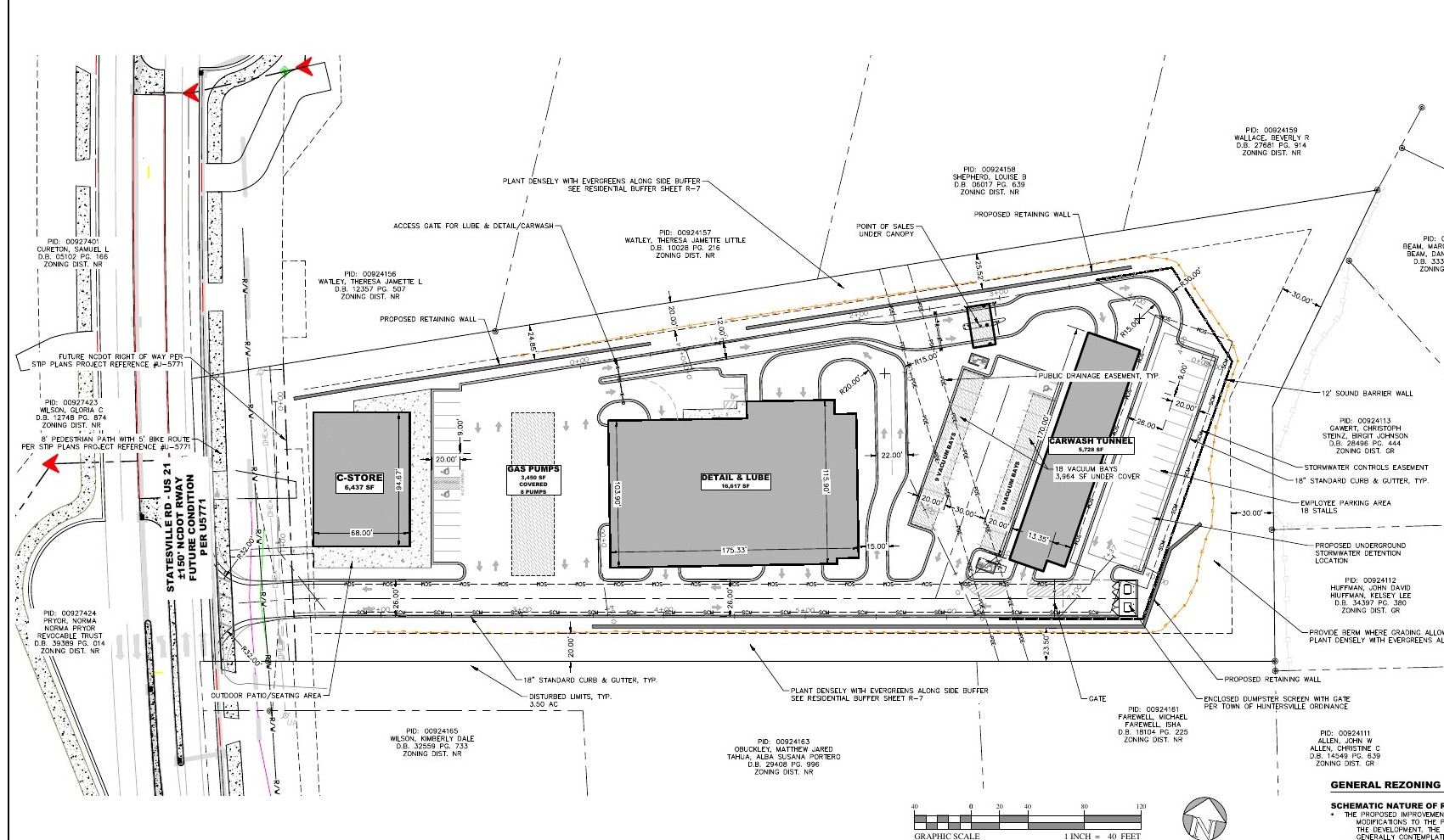
Our argument: This is a land-use compatibility decision. Placing a car wash, outdoor vacuum activity, vehicle circulation, and service operations near residential boundaries creates concerns about noise, headlights, privacy, and everyday enjoyment of neighboring homes. Those concerns follow from the proposed layout; the plans do not quantify their eventual severity.
Existing neighbors would live with the consequences.
- The car wash, vacuum area, rear drive aisle, screening wall, and stormwater infrastructure are shown near the rear residential boundary.
- The rear edge directly adjoins residential parcels, including the parcel labeled Huffman on the drawing.
- The side drive aisles and proposed retaining walls run alongside neighboring residential parcels.
These plans show property boundaries and buffer dimensions. They do not establish a verified distance from each proposed building or activity to each neighboring house. A buffer width is not a house-to-business setback.
BUFFERS & SCREENING
Less buffer space. A 12-foot wall. A compatibility problem.
| Plan detail | What the drawing says |
|---|---|
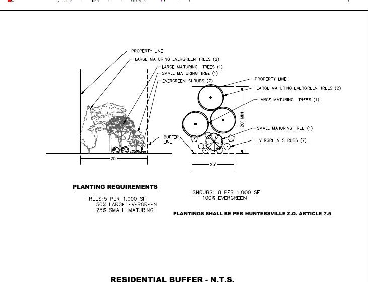
| Side buffer modification | A request to reduce the 30-foot side-property-line zoning buffer to 20 feet on the subject parcel, with dense evergreen planting. |
| Rear sound barrier | A 12-foot sound barrier wall is labeled along the rear edge. |
| Grading and retaining walls | Retaining walls are shown along the side edges and near the rear; a rear berm is proposed where grading allows. |
| Landscape screening | The landscape plan calls for evergreen screening along the side and rear buffers. |
All affected neighbors deserve equal consideration.
The site plan labels a 12-foot sound barrier along the rear boundary beside Hamptons properties. It does not show a comparable sound barrier along the side boundaries beside neighboring Statesville Road residential properties. Retaining walls and planting shown elsewhere should not be assumed to provide equivalent acoustic protection.
Why is noise protection concentrated at one residential edge? Statesville Road neighbors also deserve an assessment of the development’s effects on their daily lives, outdoor spaces, and privacy. The applicant and town should explain the difference in treatment and evaluate every affected residential boundary—not just the Hamptons side.
Calling a structure a “sound barrier” does not establish how well it will work. The materials reviewed for this page do not establish its material, acoustic absorption or transmission performance, or the expected noise reduction at neighboring properties. Height alone does not answer those questions.
- What material and construction would be used, and what acoustic performance is supported by testing?
- How much noise reduction is predicted for each affected residential property, including Statesville Road neighbors?
- How would gaps, wall ends, terrain, and elevated windows affect performance?
- Why are comparable protections not shown along all residential edges, and what evidence supports that design?
Our argument: Every affected neighbor deserves a complete assessment and equal consideration. Selective screening, without demonstrated performance, does not resolve the broader incompatibility of this commercial proposal with the people living around it.
In our view, the proposed 12-foot sound barrier wall underscores the scale of the noise and privacy concerns this development raises. A wall and new screening may be mitigation measures; they do not establish that this mix of uses belongs beside residential backyards. At the same time, the applicant is seeking less side-buffer space. Our position is to retain residential zoning.
TREE REMOVAL
Removing roughly three-quarters of the existing trees changes this site.
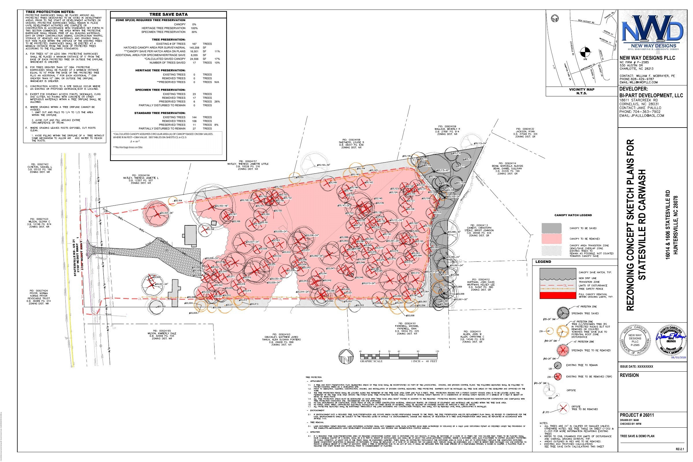
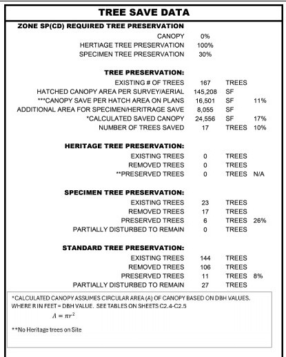
The developer’s Tree Save Data table lists 17 specimen trees and 106 standard trees for removal: 123 trees in total, or approximately 74% of the 167 existing trees counted in that table.
| Category | Existing | Removed | Preserved | Partially disturbed, remaining |
|---|---|---|---|---|
| Specimen trees | 23 | 17 | 6 | 0 |
| Standard trees | 144 | 106 | 11 | 27 |
| Total | 167 | 123 | 17 | 27 |
Our argument: Removing 123 existing trees would substantially alter the wooded setting between this site and its neighbors. New landscaping should not be presented as an immediate replacement for the size, canopy, or screening of established trees. The 27 partially disturbed trees also warrant scrutiny: remaining on the plan is different from being preserved without disturbance.
The 27 partially disturbed trees are a separate category from the 17 preserved trees. The individual-tree table’s color key says partially disturbed canopy is not included in the saved-area calculation. New planting is also distinct from retaining existing trees.
A planting plan is not an immediate replacement for a wooded boundary.
The removal of 123 existing trees should be evaluated alongside the size and placement of new planting, the disturbance to retained trees, and the time needed for screening to establish.
- Day-one screening: Show the installation height, spacing, and seasonal coverage of proposed trees and shrubs—not just their mature appearance.
- Retained-tree survival: Explain root-zone protection, grading effects, and the condition of the 27 trees listed as partially disturbed but remaining.
- Long-term reliability: Clarify enforceable responsibilities for screening, failed planting, and wall upkeep. For stormwater, RZ-6 already assigns maintenance to the owner and subsequent owners; residents need to understand how that obligation would be enforced.
- Home-specific views: Show what screening would look like from each affected residential edge, including elevated viewpoints.
Our argument: The town should evaluate what neighbors would actually experience when the site opens, as well as years later. Proposed future growth should not be treated as equivalent to the established vegetation being removed.
RUNOFF & WATER QUALITY
Protect neighboring homes—and Torrence Creek.
Clearing trees, grading the site, and replacing much of it with buildings, pavement, and vehicle-use areas raises a serious question: where will stormwater go, and how will neighboring properties and downstream waters be protected?
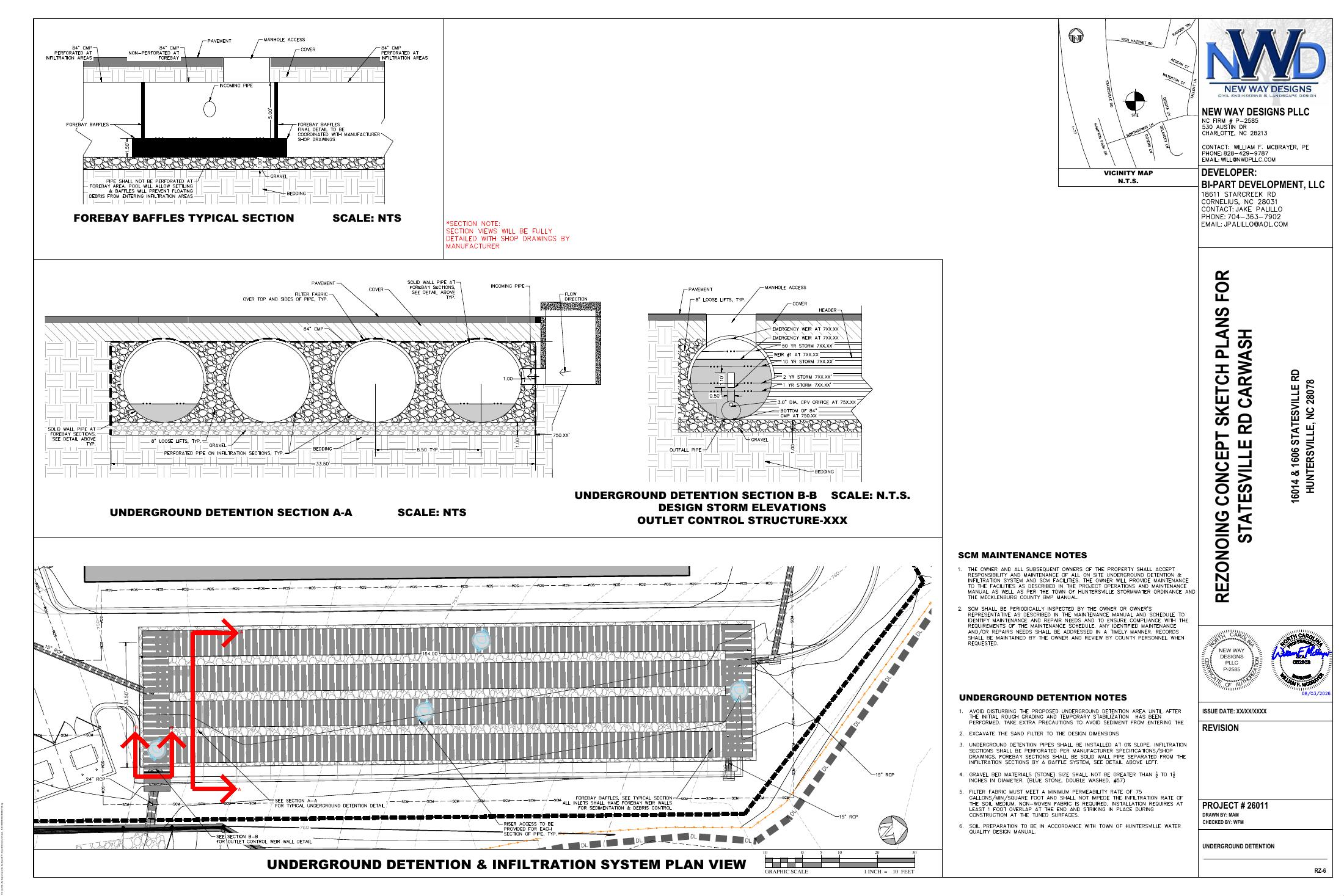
The site plan lists approximately 3.50 acres of disturbed limits and 75.34% impervious area. It shows underground stormwater detention near the rear residential edge; sheet RZ-6 describes an underground detention and infiltration system. The RZ-6 maintenance notes assign responsibility to the owner and subsequent owners and call for periodic inspection. The engineering review still needs to establish system performance and downstream protection.
Our concerns extend beyond the property line.
- Neighboring homes: Changes in grading, drainage routes, and runoff could affect adjoining yards and homes if stormwater is not adequately managed. Residents need clear evidence that flows will not be redirected or concentrated onto their properties.
- Torrence Creek: Residents want the receiving drainage path identified and any connection to Torrence Creek explained, including how sediment and pollutants would be kept out of the creek.
- Construction: Extensive clearing and exposed soil make erosion and sediment control especially important during site work, before permanent landscaping is established.
- Commercial operations: A gas station, vehicle service uses, and car wash warrant scrutiny of spill prevention, stormwater treatment, and the separation of car-wash wastewater from storm drainage.
Our argument: Neighbors should not bear additional drainage or water-quality risk to accommodate this commercial rezoning. The town should evaluate the cumulative effect of tree removal, impervious surfaces, grading, and the proposed uses—not treat underground storage as a complete answer on its own.
Questions the applicant and town should answer.
- Where does runoff leave the site, and what is the downstream route to receiving waters?
- How do existing and proposed runoff volumes, peak flows, and drainage patterns compare?
- What protects adjoining homes during major storms and if the drainage system overflows or becomes blocked?
- How would the specified treatment and maintenance measures perform, and how would inspections and repairs be enforced to protect downstream waters?
These are concerns and requests for verification. The reviewed plan images do not establish a confirmed discharge route to Torrence Creek or prove that neighboring homes will flood. Supporting drainage calculations, outfall mapping, and engineering review are needed to assess those impacts.
Review the underground detention and infiltration plan (RZ-6)
DAILY LIFE BESIDE THE SITE
Evaluate the combined impact—not each business in isolation.
Neighbors would experience the whole site: pumps, vehicle servicing, the car wash, outdoor vacuums, drive aisles, lighting, deliveries, and waste collection. A review of one component cannot explain what living beside all of them would be like.
Noise and operating hours.
The plan shows 18 vacuum bays and a car wash tunnel at the residential end of the property. Residents need an assessment of equipment noise, car-wash exit noise, vehicle movements, and service activity together—not just individual equipment specifications.
- What binding hours would apply to each use, including vacuums, deliveries, and cleanup? Those limits are not established in the reviewed engineering sheets.
- What would an acoustic study predict at adjoining property lines and outdoor living spaces, including when multiple systems operate together?
- How would wall height, gaps, terrain, and equipment placement affect screening? Would noise travel around the wall or reach elevated windows?
- Which operating limits would be binding and enforceable if the property changes operators?
Headlights, lighting, and privacy.
The drive aisles and rear activity areas warrant a closer look from the neighboring homes’ perspective. A landscaping illustration does not establish what residents would see at night or before new planting matures.
- Provide a photometric plan showing light levels at residential boundaries, fixture heights, shielding, canopy lighting, and illuminated signs.
- Show vehicle approach directions and potential headlight exposure to adjoining yards and windows.
- Illustrate views from neighboring yards and upper-floor windows using verified elevations and proposed planting sizes.
Fuel and oil storage near households using well water.
The reviewed site-plan sheets do not identify the locations of gasoline storage tanks or oil storage associated with the proposed fueling and vehicle-service uses. Some neighboring Statesville Road residents have self-reported that their households rely on well water. That makes storage location, leak and spill prevention, and groundwater protection important questions for those residents.
- Where would gasoline tanks and any new- or used-oil storage be located, and would each be above or below ground?
- What are the proposed capacities, containment measures, leak-detection systems, and spill-response procedures?
- How would the locations relate to nearby private wells, groundwater conditions, and drainage routes?
- What review and protections would address the neighboring households that report using well water?
Our argument: People who rely on private wells deserve a clear explanation of these risks and safeguards before the town considers introducing fuel and oil storage beside their homes. A pump canopy and service-building footprint do not answer where storage would be placed or how groundwater would be protected.
Well use is resident-reported, not independently verified here. This page does not claim that contamination has occurred or will occur. Storage locations and protective measures need to be identified and evaluated.
Traffic, queues, and access.
The site plan places access on Statesville Road and shows internal circulation among several vehicle-oriented uses. The review should account for their combined demand and how queues or turning movements interact with the corridor.
- The cover sheet identifies a traffic impact analysis as “in progress by Davenport.” Review the completed analysis, including turning movements and queues for the gas station, car wash, and service operations together.
- Explain how vehicle queues would remain on site without blocking access, circulation, or pedestrian routes.
- Address driveway safety and compatibility with planned road and pedestrian improvements, supported by the relevant agency review.
These are requests for evidence. This page does not claim that a noise limit, lighting standard, or traffic requirement has been violated.
LAND-USE COMPATIBILITY
The first question is whether this use belongs here.
The site plan identifies the existing zoning as Neighborhood Residential (NR) and the proposed zoning as Highway Commercial Conditional District (HC (CD)). That is a consequential change in the relationship between this parcel and the homes around it.
Our opposition is to this commercial rezoning—not an invitation to negotiate which commercial tenant would be least disruptive. Residential zoning should be retained while the town develops a corridor plan that is compatible with neighboring communities and respectful of directly adjoining homes.
Questions for the town’s review.
- How does this rezoning align with the adopted plans that apply to this specific parcel and corridor?
- How would the intensity, location, and operation of the proposed uses relate to the surrounding residential properties?
- What is the justification for reducing the side buffer, and how does that request affect residential compatibility?
- Which protections would be enforceable conditions, and which are illustrative intentions that could change during final design?
The page does not assert a violation of the zoning ordinance or a conflict with a specific adopted policy without a verified citation. Applicable ordinance provisions, planning documents, and staff findings should be reviewed together before making those claims.
WHAT REMAINS UNANSWERED
Drawings alone do not resolve these impacts.
The reviewed packet includes site, grading, tree, landscape, and stormwater sheets. It also includes tree-protection and maintenance notes and identifies a traffic study as in progress. The items below identify the supporting evidence or implementation details still to verify—not a claim that every item is absent or has never been submitted.
| Evidence to verify | Why it matters to neighboring homes |
|---|---|
| Measured residential-edge overlay | Establishes actual distances to homes, yards, windows, and proposed activities. |
| Combined acoustic assessment and operating hours | Tests residential noise exposure and the effectiveness of the sound barrier. |
| Traffic and queue analysis | Tests turning movements, pedestrian conflicts, internal circulation, and spillback. |
| Photometric and headlight assessment | Shows nighttime effects at property lines and residential viewpoints. |
| Drainage calculations and downstream mapping | Explains changes in flow, overflow routes, protections for homes, and any connection to Torrence Creek. |
| Tree protection and planting implementation | RZ-2.1 and RZ-7 contain protection and planting notes. Verify their site-specific implementation, retained-tree survival, and screening available at opening. |
| Fuel and oil storage plan; private-well assessment | Identify storage locations, containment and leak detection, and protections for neighboring households that report using well water. |
| Written enforceable conditions and agency comments | Distinguishes binding protections from concepts or assurances. |
WHY MITIGATION DOES NOT SETTLE THE QUESTION
A wall, new planting, and detention are not a land-use compatibility finding.
| Proposed measure | What still needs to be demonstrated |
|---|---|
| 12-foot sound barrier wall | Its material, tested acoustic performance, expected noise reduction, and visual effect; why comparable barriers are not shown along the Statesville Road residential edges. It does not itself address traffic or drainage. |
| Evergreen planting | Coverage at installation, time to maturity, upper-floor views, and reliable maintenance. |
| Underground detention and infiltration | Capacity, treatment, overflow routing, downstream effects, and long-term maintenance. |
| Side buffer reduced from 30 to 20 feet | Why less separation is appropriate beside residential properties and what protects those neighbors. |
Our argument: The need for substantial mitigation deserves careful examination. Even effective mitigation of one impact would not establish that the full commercial program is appropriate for this residential setting.
WHAT WE ARE ASKING
Deny R26-13. Retain residential zoning.
We are not asking the town to choose which commercial business would be the least disruptive here. We are asking it to protect the current residential zoning and develop a thoughtful plan for this section of Statesville Road that is compatible with surrounding communities and respectful of the homes directly beside it.
The town should evaluate the proposal as a whole: commercial activity at residential boundaries, removal of 123 trees, reduced side buffers, and unresolved questions about noise, privacy, traffic, runoff, and water quality. Our position is that this combination does not fit this residential setting.
SOURCE PLANS
Which plans support this page?
Reviewed October 4, 2026. The detailed figures and illustrations on this page come from the engineering packet stamped August 3, 2026: RZ-4 (site plan), RZ-2.1 (tree summary and demolition plan), RZ-2.2 (individual-tree tables), RZ-6 (stormwater), and RZ-7 (landscape plan). The September 10 meeting packet was also checked; its site sketch is stamped June 10, 2026. Distribution date and drawing date are different, so that packet is not treated as newer engineering. These are concept drawings, not a construction approval. Check the town case page for subsequent revisions.