TOWN PLANS
Does R26-13 align with the plans for this community?
The 1998 Rich Hatchett neighborhood plan, Huntersville’s 2040 Community Plan, and the Statesville Road widening project should be considered together. Our case for denial is grounded in where development belongs, how it treats existing residents, and whether it supports the corridor’s long-term design.
ON THIS PAGE
THE CENTRAL ARGUMENT
Plan the corridor around the people who already live here.
R26-13 would introduce a gas station, convenience store, car wash, vehicle-service building, and 18 vacuum bays on a currently residentially zoned site beside existing homes. The August 3 engineering plans label eight pumps, propose removing 123 of 167 counted trees, and request a reduction of the side buffer from 30 feet to 20 feet.
The question is not whether Huntersville needs to accommodate growth. It is whether this combination of uses, intensity, outdoor activity, and residential-edge treatment advances the plans for this particular place.
Review the August engineering plans · Read our detailed proposal review
1998 NEIGHBORHOOD PLAN
A plan built to protect an established community.
The Rich Hatchett Road community and Huntersville’s Planning Department prepared this plan collaboratively. Its cover records approval by the Board of Commissioners on August 17, 1998. The history describes a long-established African American community with multigenerational ties to the land, surrounded by newer subdivisions, Interstate 77, and commercial growth.
The plan records concerns about traffic, noise, and light pollution. It also describes opposition to an earlier outdoor amusement proposal because of its incompatibility with nearby homes. These are not new concerns created by R26-13; they were central to the neighborhood’s planning process.
Residential character was the starting point.
The planning process sought to guide undeveloped tracts in a way compatible with both town and neighborhood goals. Residents wanted most of the community to remain predominantly residential. The plan did identify three areas where conditional nonresidential or mixed-use development could be considered, but attached restrictions to that possibility.
Read the community history — PDF page 3 · Read the planning goals — PDF page 5
LOCATION & LAND USE
The commercial exceptions were limited—and conditional.
The implementation section identifies Area 1 on the east side of Statesville Road, north of Rich Hatchett Road; Area 2 across Statesville Road on the west side; and Area 3 along I-77 without direct Statesville Road frontage. It calls for conditional site plans that control scale, lighting, landscaping, traffic generation, and outdoor activity.
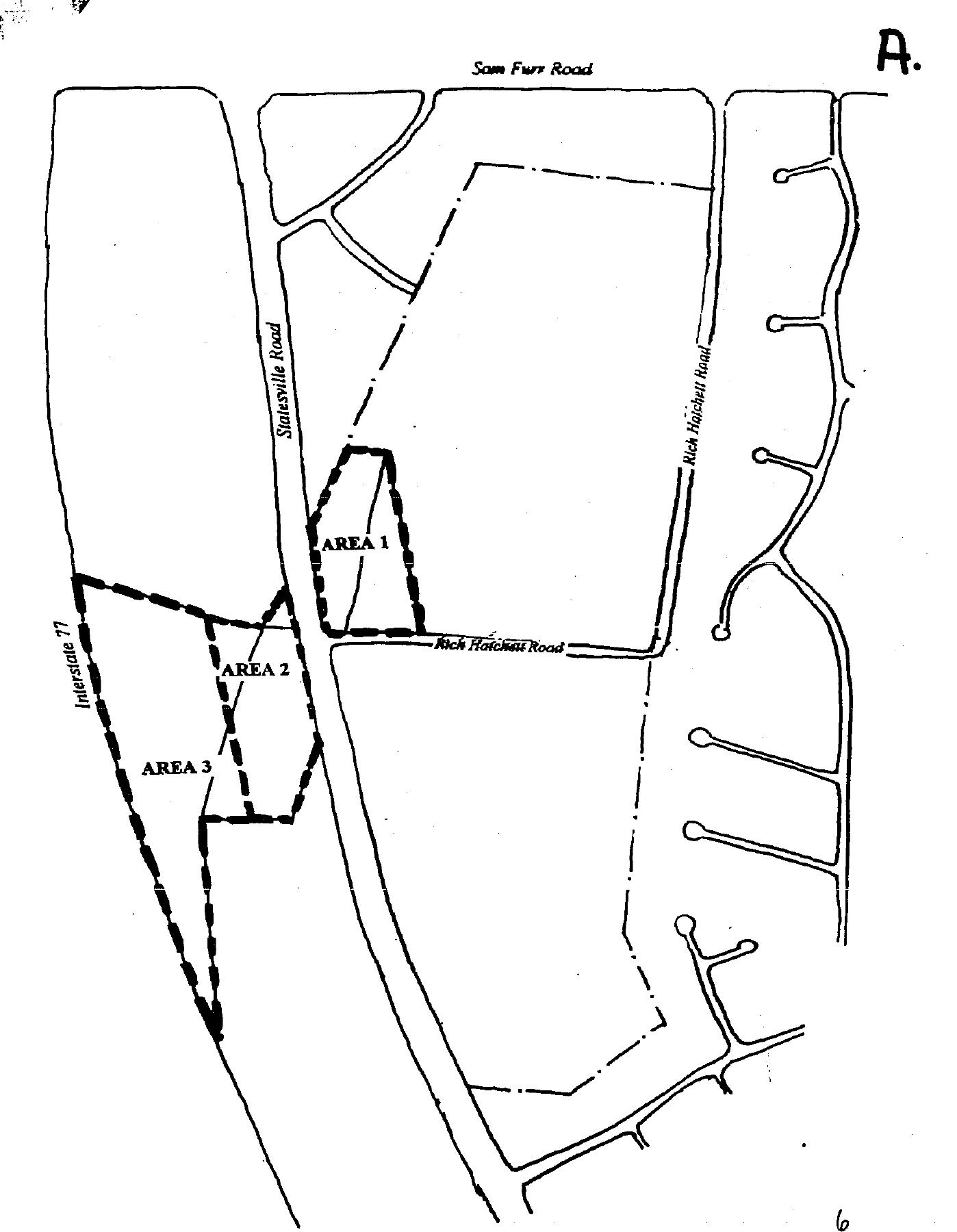
The proposed site is not interchangeable with the three designated areas.
The site outline in the town’s May 13, 2026 packet is east of Statesville Road and south of Rich Hatchett Road. Map A places Area 1 north of Rich Hatchett Road and Areas 2 and 3 west of Statesville Road. Comparing these documents raises a substantial location conflict with the plan’s limited commercial exceptions.
This comparison uses the published maps rather than a surveyed parcel overlay. The town should confirm the historical plan boundary and its application to parcel 00924160.
Even the designated commercial areas excluded gasoline stations.
Exhibits 1, 2, and 3 list gasoline stations among prohibited uses. Exhibits 2 and 3 additionally list car washes and vehicle sales, service, rental, cleaning, and repair. Area 1’s shorter list should not be represented as containing those additional exclusions.
The distinction strengthens the case: the plan contemplated commercial development without accepting every automobile-oriented use. A gas station conflicts with the use recommendations in all three exhibits; car washes and vehicle services are expressly excluded in Areas 2 and 3.
Scale and tree retention were part of the bargain.
Area 1 recommends a maximum building footprint of 6,000 square feet; Area 2, 8,000; and Area 3, 20,000. All three require a demonstrated commitment to tree retention and landscaping. RZ-4 labels the proposed detail/lube building 16,817 square feet and the convenience store 6,437 square feet. Those figures raise scale concerns when compared with the neighborhood-edge recommendations, but Area 3’s larger allowance cannot be transferred to an east-side parcel.
The tree table proposes removing approximately 74% of the counted existing trees. That is a serious tension with the plan’s tree-retention direction, even though the plan does not prescribe a numerical preservation percentage.
Implementation — PDF page 7 · Area 1 — PDF page 9 · Area 2 — PDF page 10 · Area 3 — PDF page 11
Questions that need answers
- Does the town agree the subject parcel lies outside the three identified commercial areas? Publish a parcel-specific overlay and explanation.
- What later adopted policy, if any, changes the 1998 plan’s geographic or use recommendations for this site?
- How would the proposed uses, building footprints, outdoor activity, and tree removal be reconciled with the plan rather than evaluated against isolated excerpts?
HUNTERSVILLE 2040
Town Core does not mean unrestricted commercial development.
The town’s May 13 pre-development packet shows the subject site within the Town Core character area. Its accompanying description emphasizes traditional neighborhood planning, connected streets, short blocks, and walkability. It also allows some nonresidential development through small-area plans and other qualifying locations.
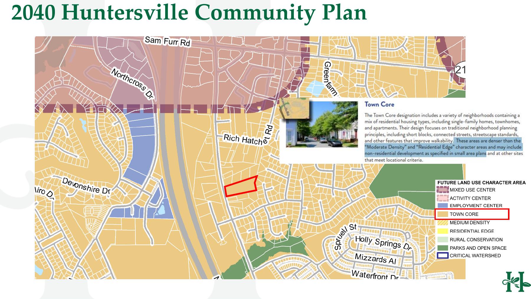
Commercial use is supported—but the proposal still has to fit.
LU 6.2 expressly encourages commercial uses in Town Core and as specified in adopted small-area plans. LU 6.3 supports small-scale neighborhood-serving commercial and office uses at key locations when their design responds to the surrounding context (plan page 64; PDF page 33).
That language must be acknowledged. Our opposition is to this proposed combination of uses and site design beside existing residents. Town Core is not a prohibition on commerce, and the 1998 plan’s use exclusions should not be described as restrictions expressly repeated in the 2040 Plan.
LU 7.1 provides a concrete design test.
For Town Core, the plan calls for buildings to front public streets or open space, connected streets with short blocks and sidewalks, improved pedestrian and vehicle connectivity, and parking predominantly behind buildings with screening and landscape breaks (plan page 64; PDF page 33).
The town should compare those principles with the actual RZ-4 layout: building entrances, the fueling canopy, drive aisles, parking, wash queues, and pedestrian routes. The street-facing appearance of one building cannot explain how the whole multi-use site meets the plan’s design direction.
A frontage sidewalk alone does not establish walkability. Readers should be able to see a continuous, safe route from that sidewalk to each customer entrance, how it crosses vehicle circulation, and how the development connects to surrounding destinations.
Neighborhood protection and meaningful transitions are explicit policies.
The full Huntersville 2040 Community Plan contains two directly relevant neighborhood policies (plan page 68; PDF page 35). LU-11.1 calls for safeguarding neighborhood character against adverse development effects. LU-12.3 calls for new development to fit existing neighborhoods through building transitions, open space, buffers, and site design.
Policy descriptions are paraphrases of the full plan. They support the planning comparison below; they are not an official finding on R26-13.
Our assessment is that reduced side buffers, substantial tree removal, outdoor activity beside homes, and unresolved screening performance work against those protections. A 12-foot rear barrier shown toward the Hamptons does not establish an effective transition along every residential boundary, particularly the Statesville Road sides.
Infrastructure should precede increased intensity.
The implementation chapter cautions against preemptive up-zoning before the appropriate infrastructure is in place (plan page 61; PDF page 31). LU 5.1 places more intense development where transportation infrastructure and utilities already exist; LU 5.2 calls for traffic analysis when generation thresholds are exceeded (plan page 64; PDF page 33).
Those provisions make current capacity, opening-day access, utility service, and the status of the planned widening relevant to the decision. A future road project does not demonstrate that adequate infrastructure exists today, and the reviewed engineering cover sheet’s unfinished traffic study does not establish acceptable operations.
Tree canopy, stormwater, and light are planning issues.
EOS 4.1 encourages heritage-tree preservation, and EOS 4.5 addresses a healthy urban forest, including canopy in Town Core (plan page 84; PDF page 43). Removing 123 counted trees warrants a specific explanation of the remaining canopy and the time needed for replacement planting to provide meaningful screening. The plan does not establish a universal tree-removal percentage that this proposal can be said to violate.
EOS 5.3 encourages low-impact development and better integration of stormwater features with open space; EOS 6.2 seeks reduced light pollution (plan page 86; PDF page 44). The drainage design, water-quality measures, lighting, and treatment of residential edges should be evaluated against those directions.
The plan describes Torrence Creek restoration as a water-quality investment (plan page 85; PDF page 43). Our concern is whether this development protects that investment and neighboring properties. A verified downstream drainage route and completed calculations are needed before asserting a particular discharge to the creek or predicting flooding.
Questions that need answers
- How does staff weigh LU 6.2’s commercial support against LU 6.3’s context-sensitive scale, LU 7.1’s design principles, and LU 11.1’s neighborhood protection?
- How does the project demonstrate walkability and connected neighborhood design beyond simply providing a frontage sidewalk?
- How do LU-11.1 and LU-12.3 apply to the side-buffer reduction, tree removal, and unequal screening treatment?
- Does the 2040 Plan modify the 1998 small-area recommendations for this parcel, or rely on them? Identify the specific provision.
STATESVILLE ROAD WIDENING
A transportation project is not a justification for this land-use change.
NCDOT’s U.S. 21 project covers Statesville Road between Gilead Road and Westmoreland Road, through projects U-5771 and U-5767. The program proposes additional lanes, a center median, bicycle and pedestrian accommodations, and redesigned intersections. NCDOT’s project highlights say a four-lane alternative with innovative intersections was selected.
Read the NCDOT project overview · Read the selected project approach
The town’s May 13 packet also includes a road-project illustration near the subject site. It provides useful context, but a presentation image should not be treated as a current approved driveway plan, construction schedule, or guarantee of future access.
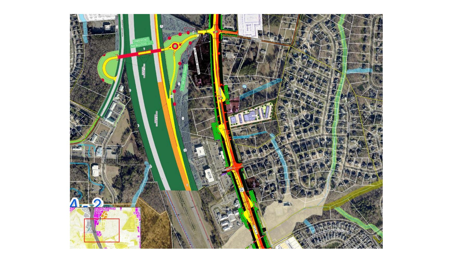
Analyze access under the future road configuration.
A center median and redesigned intersections can change permitted turning movements and travel routes. Review should identify the actual approved driveway movements, where drivers would turn around if necessary, and how customers, delivery vehicles, and service traffic would enter and exit. These are questions to resolve, not claims that a particular movement has already been prohibited.
Test the whole site’s traffic—not only one use.
The engineering cover sheet identifies a traffic impact analysis as in progress by Davenport. The completed analysis should account for the gas station, wash, vacuums, store, and vehicle servicing together. It should test queues, internal conflicts, and access under both opening-day and future-road conditions, with the assumptions and agency comments available for public review.
The 2040 transportation policies reinforce this review.
T 4.1 seeks a road system without traffic deaths or serious injuries; T 4.3 emphasizes access management. T 5.1–5.3 call for context-sensitive improvements, evaluation of NCDOT projects against community objectives, and Complete Streets design that considers all users (plan pages 100–101; PDF page 51).
The same pages specifically address U.S. 21 improvements and request stronger bicycle and pedestrian access. T 6.5 says future road connections, cycling and walking connectivity, and transit must be considered as development projects deliver incremental improvements (plan page 102; PDF page 52).
These are concrete grounds to scrutinize driveway conflicts, crossings, future access, and the relationship between the site plan and road project. They do not establish that every new driveway is prohibited or that the widening itself conflicts with the plan.
Protect the corridor’s pedestrian and bicycle investment.
The review should show how driveways cross the future walking and cycling facilities, how drivers see people at those crossings, and how routes continue across the site frontage. Adding travel lanes does not resolve conflicts between turning vehicles and people walking or cycling.
Coordinate land, drainage, and construction.
The site plan should be checked against current right-of-way needs, road elevations, utility relocation, drainage design, and construction staging. If those change the usable frontage or grading, the town needs to understand the consequences for buildings, circulation, landscaping, and already reduced side buffers.
No exact widening completion date, site-specific access restriction, or final right-of-way taking is asserted here. Archived NCDOT meeting maps are historical context, not the final design.
Questions that need answers
- Provide the current NCDOT alignment, right-of-way, driveway review, and approved access movements for this frontage.
- Publish the completed traffic study and agency comments, including future median and intersection assumptions.
- Where would queues form, and how would they avoid blocking circulation or walking and cycling routes?
- How would road grading, drainage, utilities, and construction affect the proposed site layout and neighboring properties?
- If opening occurs before widening, what conditions would apply during the interim and road construction?
A COMPLETE PLANNING REVIEW
The documents should be reconciled before a decision.
The strongest review connects the plans rather than treating each in isolation. The 1998 neighborhood plan addresses location, uses, scale, and resident protection. The 2040 framework addresses character and transitions. The road project addresses transportation design and access.
What a meaningful public explanation should include
- A location finding: a parcel overlay identifying the 1998 areas and the current 2040 character area.
- A policy comparison: the specific applicable recommendations, any later changes, and the reasons for a finding of consistency or inconsistency.
- A complete impact assessment: cumulative noise, lighting, trees, buffers, traffic, drainage, and fuel/oil storage beside homes.
- A transportation coordination record: current NCDOT comments, a completed traffic study, and the relationship between the site plan and widening design.
- Equal consideration of neighbors: an explanation of impacts and proposed screening at each adjoining residential edge.
A conditional plan, a wall, or new landscaping does not settle the underlying land-use question. Nor should missing analysis be treated as evidence that an impact is acceptable.
The comparisons on this page state residents’ planning arguments, not an official R26-13 consistency determination. The full 2040 Plan has been reviewed. The town should identify any subsequent amendments and explain the relationship between its broad commercial policies and the 1998 neighborhood recommendations.
SOURCE DOCUMENTS
Read the planning record.
- 1998 Rich Hatchett Road neighborhood plan
- May 13, 2026 town pre-development packet
- Huntersville 2040 plan documents
- Town staff report applying 2040 neighborhood policies — page 2
- August 3, 2026 developer engineering packet
- NCDOT U.S. 21 widening project
- NCDOT historical maps and meeting materials
- Town’s R26-13 case page
Sources reviewed October 4, 2026, including the full Huntersville 2040 Plan. References distinguish printed plan pages from PDF viewer pages. PDF links with page numbers open to the referenced page where supported by the reader’s PDF viewer.